


Storm Chasing
Storm Chase of March 15th, 2016
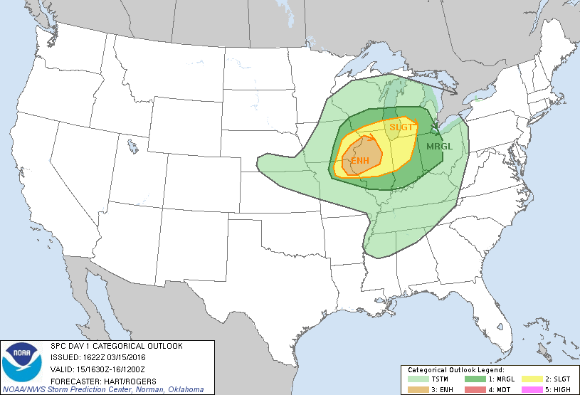
The Storm Prediciton Center's 1600z Convective Outlook.
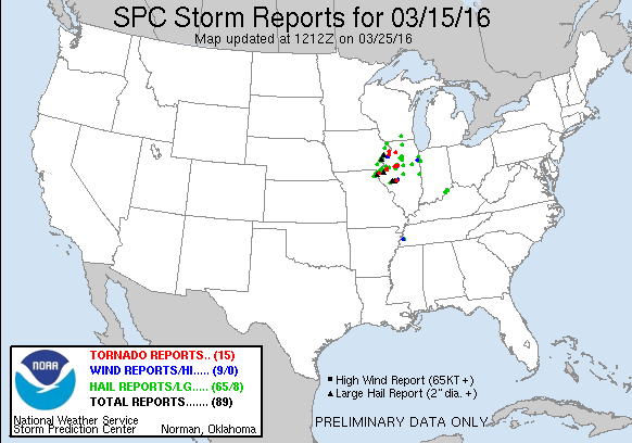
This was my first storm chase of 2016. I had been watching this event since the week before, and I thought it looked like a pretty good set up. Unlike my last two storm chases in 2015, there was an abundance of instability, as well as a lot of wind shear. The main concerns of this event were moisture, storm mode, and timing. The forecast models, especially the NAM, overdid the moisture, but underdid the surface temperatures. The result was that when the storms did fire up, they were high-based. This is problematic if you want tornadoes. Indeed, the tornadoes didn't really stop dropping until closer to sunset.
Anyway, so my initial target area was Beardstown, IL. Beardstown was half way between the two towns I was thinking of targeting earlier in the day; Mocomb and Jacksonville. So, after work, I went and voted (it was the day of the Illinois Primary,) and then went home and had lunch. Then, I hit the road for Beardstown. I actually made it there plenty early, and had some time to spare. I learned my leason after the Rozel, Kansas tornado day, and put some sun screen on.
Now, through the day, one forecast model (the HRRR,) was very consistent on a few storms firing up north, and then one big supercell firing farther to the south. By setting up in Beardstown, I was basically hedging my bet. Sure enough, the storms did fire up to the north. I wanted to wait for the southern supercell to fire up, but I became concerned that it wouldn't happen until after dark. So I headed after the northern storms.
One of the storms received a tornado warning as I drove. I can't remember at this time if it actually dropped a tornado or not. But the storm ahead of that one started to look better and better. So I set up shop a ways ahead of it, south of Macomb by a ways. From that spot, I could the rain-free bases of both storms. The easternmost storm dropped a couple of wall clouds. Eventually, I had to started heading north after it. But before I went, I saw something which looked like either a mesocyclone really wrapping up, or a shelf cloud forming (it was kind of far away at this point, hard to tell.) It turns out, it was a mesocyclone really wrapping up.
Soon after, a tornado was reported on this storm, near Good Hope, IL. I couldn't see it. As I chased the storm, alternating between heading north and east, more tornado reports came in. As I neared the town of Bushnell, I thought I saw something in the difference. Behind som trees and some buildings, I saw what looked like the right side of a tornado. But I couldn't be sure. Later on, my intern at work Joe Prado posted a picture on my facebook of what I saw, but from much closer. It was a tornado.
I continued to chase after the storm, but I was quickly overtaken by the RFD. I had to punch my way through hail and rain so heavy I literally could not see the road ahead of me. Eventually I gained some head way and made it out of the rain. At this point, it was getting dark out, and I was too far behind the storm to see anything. So I headed back towards Peoria.
Along the way, I was driving through a town (I don't remember which,) and all of a sudden, the tornado sirens started going off. I brought up the radar on my laptop, and sure enough, I was in the south end of a tornado warning. I can't remember if there was a tornado reported at this point or not. But it was heading towards Peoria. So I decided I would keep heading towards home, and spot anything if I could. I one point, I was supposed to turn on to I-474, but I missed my turn and had to loop around for like 15 minutes to get back on.
It turns out that it was very lucky that I did miss that turn. If I hadn't, I probably would have driven through a confirmed EF-0 tornado. Granted, this was a very weak tornado. But, I'm willing to bet that tornadoes and Mustangs don't mix. As it was, I drove up through the back side of the storm and the RFD. Once again, I was pounded by hail and blinding rain. I was driving up Illinois 6, where the speed limit is 70 MPH, only doing 20 MPH.
Eventually I made it home. No damage at my apartment. I considered waiting until the storm passed, and then heading out again and trying to get some lightning pictures. But at that point, I was pretty exhausted, and I still had to work at 5 AM the next morning. So I stayed home instead.
So, at the end of the day, I've started 2016 off with 1 possible tornado. I don't really feel bad about not coming away with any awesome tornadoes pictures on this day. For one, I haven't seen any really good tornadoes pictures from this event. And two, I feel like I did everything I could based on the information I had. That supercell to the south that the HRRR showed? It did happen, only a couple hours later than the forecast model had shown. And it did in fact drop a tornado near Springfield. Anyway, it's still very early in the season, and with the declining El Nino, I'm sure to get more storm chasing opportunities.